To read a topographic map for survival and prepping purposes, start by examining the contour lines, which represent elevation changes crucial for navigating terrain. Closely spaced lines indicate steep areas, useful for identifying potential natural barriers or ambush points, while wider spaces show gentler slopes that can be more accessible for travel or setting up camp. Utilize contour intervals to gauge elevation changes, helping you locate key features like peaks for vantage points and valleys for water sources. Understanding the map scale is vital for accurate distance estimates, aiding in planning routes for bugging out or gathering resources. Always check the legend for symbols that represent terrain features, which can inform you about the best locations for shelter or food. Additionally, be mindful of magnetic declination, as it can significantly affect navigation, especially in wilderness survival scenarios. Mastering these map reading techniques can enhance your preparedness and increase your chances of survival in the wild.
Key Takeaways
- Contour lines indicate elevation changes; closely spaced lines represent steep terrain, while wider lines indicate gentler slopes, crucial for planning survival routes and setting up camp.
- Identify key features: peaks are shown as concentric circles, valleys as “V” shapes pointing uphill, and cliffs as solid bands of tightly packed lines, which can aid in navigation and locating resources.
- Understand contour intervals which reflect vertical changes; smaller intervals imply gradual slopes, while larger ones indicate steeper terrain, helping you assess the difficulty of traversing areas.
- Use map scales to convert distances on the map to real-world measurements; a common scale is 1:24,000, essential for accurate planning during expeditions.
- Check the map legend for symbols and colors representing terrain features, and be aware of magnetic declination for accurate navigation, ensuring you stay oriented in the wilderness.
Understanding Contour Lines
Understanding contour lines is essential for survivalists and preppers looking to navigate and interpret topographic maps effectively, as they provide crucial information about the terrain’s elevation and shape.
Contour lines connect points of equal elevation, helping you identify steepness through their spacing, which can be vital for planning routes in the wild. Close-spaced lines suggest rapid elevation changes, indicating areas that may be difficult to traverse, while wider spaces indicate gentler slopes that may be easier for movement or setting up camp.
The contour interval, which represents the vertical distance between these lines, is important for gauging elevation differences accurately, which can affect your strategy for travel and resource gathering.
Look for index contour lines, which are thicker and labeled, appearing every fifth line for easier reading. Additionally, concentric circles signify peaks, which can be advantageous lookout points, while tick-marked circles indicate depressions, which may serve as natural water sources or shelter options.
Understanding these features can significantly enhance your preparedness and navigation skills in the wilderness.
Visualizing Terrain Features
To visualize terrain features effectively for survivalism and prepping, it’s crucial to analyze the patterns formed by contour lines on the map.
Pay close attention to the spacing of these lines; they indicate the steepness and slopes of the land, which can be vital for planning safe routes and identifying potential shelter locations.
Recognizing distinct shapes, like “V”s for valleys that may provide water sources and concentric circles for peaks that offer vantage points, will help you identify key geographical elements for survival situations.
Understanding Contour Line Patterns
Contour lines are essential for understanding the terrain features you might encounter during survival situations and prepping. These lines not only indicate elevation but also provide insight into the landscape’s characteristics.
By connecting points of equal elevation, contour lines help you visualize the terrain‘s shape, which is crucial for planning routes or identifying potential shelters. On large scale maps, you’ll often see concentric circles representing peaks and tick-marked circles for depressions, signaling areas where elevation decreases, which can be vital when scouting for resources.
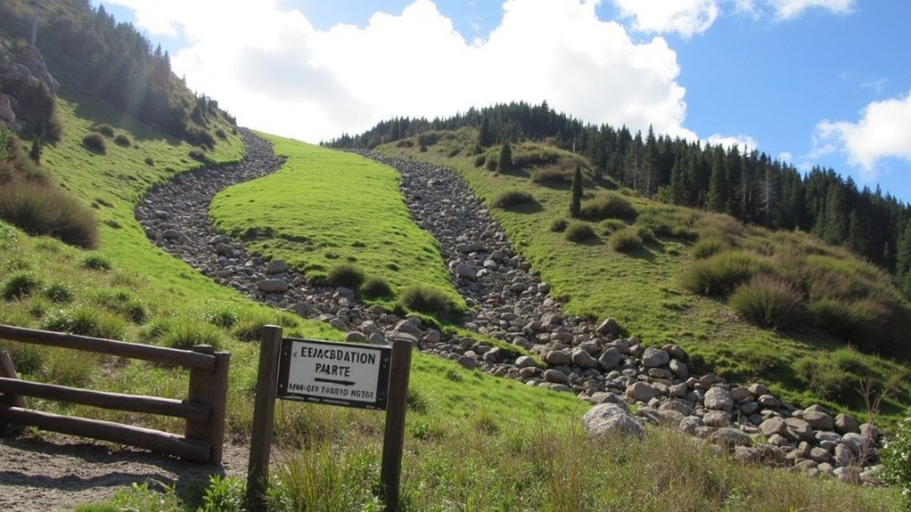
Valleys are depicted as “V” or “U” shapes that point uphill, indicating safe pathways for navigation, while ridges will point downhill, which can be important for avoiding hazardous areas.
Keep an eye out for index contour lines; these thicker lines, marked with specific elevation values, allow you to quickly gauge changes in elevation, facilitating efficient navigation as you prepare for any survival scenario.
Identifying Steepness and Slopes
When navigating a topographic map for survival and prepping scenarios, recognizing the steepness and slopes of terrain is crucial for effective route planning. Closely spaced contour lines indicate steep slopes, signaling rapid elevation changes that could impact your movement and the accessibility of resources. Conversely, widely spaced lines reflect gentler inclines, which may be more manageable during an emergency.
For example, cliffs are often represented as solid bands of tightly packed lines, indicating areas to avoid or strategically assess for potential shelter. Peaks appear as concentric circles, with the innermost circle marking the highest elevation, which can be vital for visibility and strategic advantage.
Additionally, an understanding of contour intervals—the elevation difference between adjacent lines—enhances your ability to gauge steepness and plan your approach accordingly. Valleys often display “V” or “U” shapes pointing uphill, which can guide you in identifying safe routes for travel or escape. Ridges show the opposite pattern, helping you navigate through varied terrain effectively.
Mastering these topographic features is essential for anyone serious about survivalism and prepping, as it equips you with the knowledge to traverse and utilize the landscape to your advantage.
Recognizing Terrain Features
Understanding the layout of terrain features on a topographic map is crucial for anyone interested in survivalism and prepping. Contour lines connect points of equal elevation, helping you visualize the shape of the land, which can be vital for locating resources and planning safe routes.
Closely spaced lines indicate steep slopes, making them important to navigate carefully during an emergency, while widely spaced lines show gentle slopes that can provide easier travel. Peaks appear as concentric circles, useful for identifying high ground, while depressions are marked by tick-marked circles, which could indicate natural water catchment areas.
You can identify valleys by “V” or “U” shapes pointing uphill, which often serve as natural pathways and water sources, while ridges point downhill, potentially guiding you away from danger.
Be sure to pay attention to contour intervals, often set at 40, 50, or 100 feet, as well as color variations—like blue for water and green for vegetation—to effectively interpret the topo map for survival scenarios.
Reading Slope Steepness
To evaluate slope steepness on a topographic map for survival and prepping purposes, it’s essential to examine the spacing of the contour lines closely. When these lines are tightly packed, it indicates steep terrain, which could be critical for scouting or planning escape routes.
Conversely, widely spaced lines suggest gentler slopes, useful for establishing camps or movement paths. A cliff or very steep slope appears as lines stacked directly on top of each other, indicating no horizontal distance, which could pose a significant risk.
You can also assess steepness through contour intervals; smaller intervals imply gradual slopes ideal for traversing, while larger intervals point to steeper terrain that may require specialized skills or equipment.
Furthermore, if the contour lines form “V” or “U” shapes pointing uphill, they indicate valleys or ridges, offering insights into the landscape that can aid in navigation and resource identification. Understanding these aspects can be crucial for effective planning in outdoor survival scenarios.
Contour Intervals and Index Contours
To effectively navigate and understand elevation changes in outdoor survival scenarios, it’s crucial to focus on contour intervals on topographic maps.
These intervals indicate the vertical distance between adjacent lines, which can provide insight into potential challenges you may face in the terrain.
Index contours, marked with specific elevation values, serve as quick reference points to identify significant changes in elevation and terrain shape.
Understanding Elevation Changes
Elevation changes are a crucial consideration for survivalists and preppers, as they play a significant role in determining the suitability of a landscape for various survival scenarios. Topographic maps provide essential insights into the terrain, with contour intervals indicating the elevation difference between adjacent lines, usually ranging from 40 to 100 feet, depending on the map’s scale.
Familiarity with index contours, marked by thicker lines, allows you to identify specific elevations every fifth contour, which can be vital for planning routes or finding resources.
By analyzing the spacing of contour lines, you can assess the steepness of the terrain—closely spaced lines indicate rapid elevation changes that may present challenges for travel or shelter building, while widely spaced lines suggest gentler slopes that could be more manageable for movement or establishing a base camp.
A solid understanding of these topographic elements enhances your ability to navigate effectively through various landscapes, whether for gathering supplies, seeking shelter, or avoiding potential hazards in a survival situation.
Identifying Contour Line Types
Understanding the types of contour lines on a topographic map is essential for survivalists and preppers when navigating and assessing the landscape for potential resources and safe routes.
Contour intervals represent the vertical distance between adjacent lines, typically ranging from 40 to 100 feet. Index contours, marked every fifth line, are thicker and denote specific elevations, aiding in efficient navigation during outings.
The spacing of contour lines reveals the terrain’s steepness; closely spaced lines indicate steep slopes that may be challenging to traverse, while wider spacing signifies gentler slopes that are easier to navigate.
Additionally, tick-marked lines can show depressions, which may indicate water sources or shelters, contrasting with concentric circles that represent peaks, useful for vantage points or lookout areas.
Mastering these elements is crucial for accurately assessing elevation changes and identifying landforms that could impact survival strategies.
Map Scales and Distances
Map scales are crucial tools for survivalists and preppers, aiding in the assessment of real-world distances when navigating through diverse terrains.
On topographic maps, the scale typically displays as a ratio, such as 1:24,000, indicating that one inch on the map corresponds to 24,000 inches in real life. This precise scale is invaluable for accurate navigation in wilderness scenarios.
Topographic map scales, like 1:24,000, are essential for precise wilderness navigation, ensuring accurate distance assessments.
In contrast, a smaller scale, like 1:65,000, encompasses a larger area but sacrifices detail, which may be less useful for specific survival tasks.
To effectively estimate distances, you can utilize a piece of string or the edge of a compass.
Grasping the concept of map scales enhances your capability to plan expeditions and navigate successfully, ensuring you’re well-prepared for any outdoor challenges in your survival journey.
Interpreting the Map Legend
A topographic map’s legend serves as a crucial tool for survivalists and preppers, providing essential insights into navigating the terrain. It decodes symbols and colors that represent vital features such as roads, trails, and water sources. Contour lines illustrate elevation changes, with thicker lines indicating specific elevation values, which is critical for understanding the lay of the land in emergency situations.
| Feature | Color | Description |
|---|---|---|
| Water Sources | Blue | Lakes, rivers – essential for hydration and fishing |
| Forested Areas | Green | Wooded regions – potential for shelter and resources |
| Open Terrain | White | Non-vegetated land – useful for visibility and movement |
Understanding these elements is vital for effective navigation and planning in survival scenarios.
Magnetic Declination and Map Orientation
Finding your way with a topographic map is crucial for survival situations, and it requires a keen awareness of magnetic declination—the angle between magnetic north and true north. This angle can vary by location and change over time, affecting how you navigate in the wilderness.
Topographic maps are specifically designed to align with true north, making it essential to check the declination indicated in the map’s margin. To accurately orient yourself, adjust your compass readings by adding or subtracting this value to find true north.
Finding and Accessing Topo Maps
Where can you find reliable topographic maps to aid in your outdoor survival and prepping adventures?
Start with the U.S. Geological Survey (USGS), which offers over 54,000 maps scaled at 1:24,000, providing detailed terrain information crucial for navigation and planning.
The U.S. Geological Survey provides over 54,000 detailed topographic maps, essential for effective navigation and outdoor planning.
The U.S. Forest Service also has accessible topo maps, including FSTopo and wilderness maps, ideal for those preparing for survival situations.
For enhanced features, consider private companies like National Geographic Trails Illustrated, which offer specialized maps tailored for outdoor enthusiasts.
Additionally, mapping websites like Gaia GPS provide a premium catalog of backcountry maps that can be invaluable for scouting locations and routes.
Don’t forget to check local public land maps from national parks and forests, often downloadable for free, ensuring you have the right resources to navigate and survive in the wild.